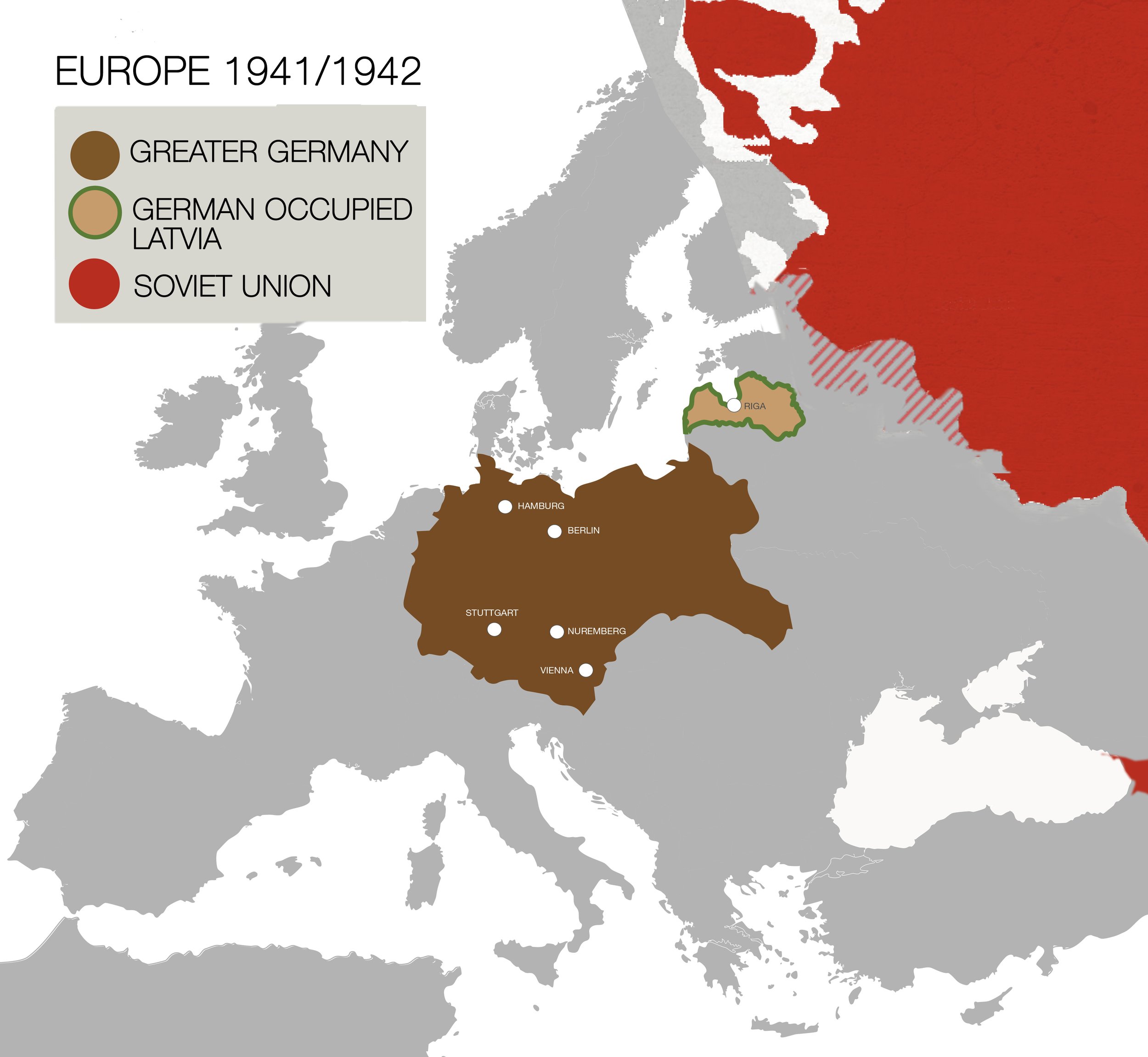
Zoomed out map of Latvia (1941)
1941/1942 map situates Latvia within a German dominated Europe, highlighting the recent German occupation of Latvia. The Soviet Union is included as a prior occupier of Latvia between 1940-1941. This map notes a Soviet winter-offensive taking place in 1941/1942 (see shaded area). The Soviet Union remained a menacing presence in the region, reoccupying Latvia from 1945-1991.
The five deporting cities: Berlin, Nuremberg, Stuttgart, Vienna, and Hamburg are indicated on the map. Transports traveled for three days and nights, without food or water, to arrive at the Skirotava train station in Riga, Prisoners were forced to march 4 kilometers in bitter cold temperatures to the Jungfernhof concentration camp..
Zoomed in map of area once
occupied by Jungfernhof Concentration Camp (2022)
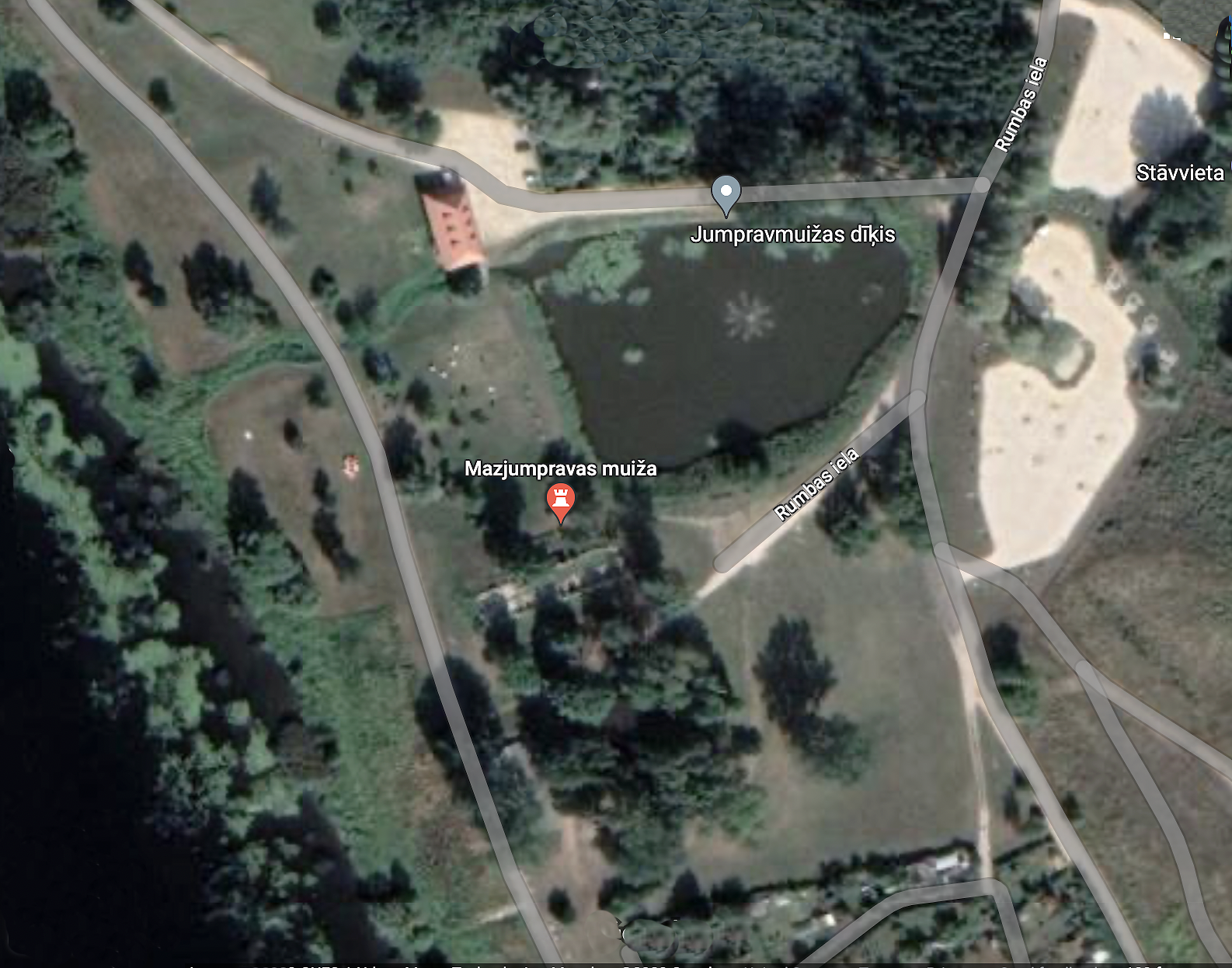
Satellite image taken from Google maps (2023)
This map features an aerial view of the site once occupied by the Jungfernhof concentration camp. Ruins from the Mazjumprava Manor are visible within a new public park designated for leisure and relaxation. Two large parking lots are recent additions.
Remotely situated, the camp was without barbed wire fencing. Prisoners were confined to the camp by an armed border patrol. There are no physical markers remaining that indicate the precise parameters of the camp.
Contemporary and Archival Maps
and Photos of Jungfernhof
There are no surviving maps or photos of the Jungfernhof concentration camp during its four years of operation. The maps and photos presented on this page depict the camp before 1941 or after 1944. These images help visitors understand where the camp was situated along the Düna river and the number of buildings located on 200 hectares/500 acres of land. Given the camp’s remote location, the camp lacked barbed wire fencing, therefore, the exact perimeters of the camp have yet to be determined.
Archival Photos of Jungfernhof Aerial View

1944 Map of Jungfernhof

1944 image, damaged photo.
First photo found by Martin P. Goettl, GISP | UW-Eau Claire Geography & Anthropology in the College Park Archive. Second photo contributed by Latvian archivist, Ivars Bergmanis. He adds, originally acquired by Latvian State Forest Research Institute "Silava" from The U.S. National Archives and Records Administration.
Further commentary by Ilya Lensky to identify year of photo: If we take the center of the city, we see cleared empty spaces and some ruins in the area of City Hall. The City Hall square and St.Peter's Church (on the right of the photo) burnt down when the Nazis were capturing the city on June 29, 1941. The ruins were gradually cleared in 1941-1942. Than, if you look at the one of the former Jewish neighborhoods, you see three major synagogues standing roofless, with inner walls visible - so this is after July 4, 1941, when the synagogues were deliberately burnt down by the Nazis..It seems that the Great Synagogue (1) also has part of the wall destroyed - it was damaged during Soviet aerial bombardments in late summer or fall of 1944. As to the camp grounds - we see the U-shaped barrack, which was installed in 1942 (we have it memoirs), while before that there was another U-shaped building, closer to the pond (two elongated barns with narrow corridor between them), which was torn down.
Third image is of a layered map, combining both maps to extract new information.

1917 German Army aerial photo, Baden-Wuerttenberg Land Archives. https://bit.lv/3j3FsEI Retrieved by Ilya Lensky (2020)
One of two historic maps of the area found in the archives, is from a WWI reconnaissance mission. The map presents the layout of land that includes the manor estate, a warehouse, and a cluster of barns and sheds.

1916 aerial photo in Estonian State Archives. No. EFA.124.A.122.6. Retrieved by Ilya Lensky (2023)
This photo indicates the isolation of the camp site and its proximity to more developed areas at a distance. Self-published memoirs describe bartering with neighboring farms for scraps of food, but the farms also appear at a distance.
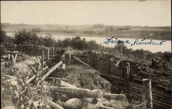
Jungfernhof Land View

Foto Ansichtskarte / Postkarte Bei Klein Jungfernhof an der Düna Lettland, Mit Holz befestigte Laufgräben, I. WK. Nr. 10.091.115. Postcard found by Fred Zimmak on Ebay.
Photo was taken for the Russian soldiers in World War I. The Germans were on the other side of the Daugava River (Düna), conducting a raid to the Russian side, stationed at Jungfernhof. Additional sources: query=jungfernhofquery=jungfernhof. https://anno.onb.ac.at/annosuche#searchMode=simple&query=jungfernhof&from=1


Herde Institut/Bildkatalog. No. 227024. Zur Mühlen (1985/1990) Baltisches Historisches Ortslexikon: Teil 2: Lettland (1990). Taken from https://www.herder-institut.de/bildkatalog/iv/227024

1993 Photo of Jungfernhof.
Archival Maps
Maps of Jungfernhof drawn by Rudolf Seck, SS Kommandant of Jungfernhof, for his trial. Retrieved from Hamburg state archives.

Map of murder. In January 1942, Seck shot five elderly male prisoners by the side of a barn. Their crime was to warm themselves in front of a fire. The map was drawn by an eyewitness to the crime. Seck forced her to watch the killings. The map was used as testimony in Seck’s trial and aided in his conviction. Retrieved from Hamburg state archives.


1947 Archival map drawn in preparation for Soviet runway. Found in Latvian archives by Ilya Lensky, indicating placement of buildings at Jungfernhof.